
Great Migration Kenya Map: Best Viewing Spots
Use our Great Migration Kenya map to find the best viewing spots. Discover expert tips on routes, river crossings, and timings for your safari adventure.
Charting Your Adventure with a Great Migration Kenya Map
Have you ever dreamed of seeing millions of wildebeest thundering across the African plains?
It is a sight that changes you forever. However, finding the herds is not always easy because they are constantly moving. This is exactly why you need a reliable Great Migration Kenya map to guide your journey. Without a proper understanding of where the animals are, you might end up staring at empty grass instead of the greatest show on earth. We want to ensure that does not happen to you.
At Mara Triangle Safaris, we use our deep knowledge of the land to position you perfectly for the action. By understanding the layout of the Masai Mara migration routes, you transform a regular holiday into a strategic expedition. A good Great Migration Kenya map acts as your treasure map, leading you directly to the heart-pounding drama of nature. It helps you visualize the scale of the ecosystem and plan your days effectively.
But there is more to it than just looking at a drawing.
You need to know how to interpret the movements relative to the season. The landscape shifts dramatically throughout the year, affecting where the animals graze. When you consult a Great Migration Kenya map, you start to see patterns that are invisible to the average tourist. You realize that the herds follow the rains in an ancient cycle of survival. We help you decode these patterns so you are always one step ahead.
Whether you are looking for the massive herds on the plains or the intense river crossings, the Great Migration Kenya map is your essential tool. It connects the dots between the Serengeti to Masai Mara migration and your specific location in the reserve. By focusing on the map, you ensure that every game drive counts. It gives you the confidence to explore deeper and experience the wild in its rawest form.
Understanding the Routes
Visualizing the Scale
Download an offline version of the map on your phone before you leave the lodge, as signal can be spotty.
Interpreting Timings on the Great Migration Kenya Map
Timing is everything when it comes to safari.
You cannot just show up any day and expect to see the magic happen. A comprehensive Great Migration Kenya map usually highlights specific months for specific areas. The herds typically arrive in the Masai Mara from the Serengeti around July and stay until October. However, nature is unpredictable, and rains can shift this schedule. When you look at the Great Migration Kenya map, pay attention to the northernmost points during these peak months.
This is when the best time to visit Masai Mara for migration aligns with the highest concentration of animals. We always advise our guests to be flexible with their dates if possible. Using the Great Migration Kenya map allows you to track the historical movements of the wildebeest. It shows you that early arrivals might cross the Sand River sooner than expected.
Let’s look at the later months.
As the season progresses, the herds move back south. A detailed Great Migration Kenya map will show the return journey towards the Serengeti. This usually happens around October or November when the short rains begin. Understanding the Masai Mara November weather is crucial here, as the storms trigger this movement. If you are planning a trip later in the year, your Great Migration Kenya map will direct you to different sectors compared to July.
It is a dynamic cycle, not a static event. We monitor these movements daily to update our guests. Even during the Masai Mara in December weather, there is plenty to see if you know where to look. The Great Migration Kenya map is relevant year-round because it helps you understand the ecosystem’s flow. It is the key to unlocking the secrets of the seasons.
The Arrival Phase
The Departure Phase
Book your safari well in advance for peak season (July-October) as the best lodges near the crossings fill up fast.
3 Days maasai mara safaris package with Mara Triangle Safaris: The Ultimate Short Break Safari Adventure
Locating Best Viewing Spots on the Great Migration Kenya Map
This is the section you have been waiting for.
Where exactly should you park your vehicle? A high-quality Great Migration Kenya map will pinpoint the famous crossing points along the Mara River. These are the stages for the most dramatic scenes of the migration. Places like Paradise Crossing or the Main Crossing are legendary spots that you can identify on the Great Migration Kenya map. Being at the right spot means witnessing the chaos of wildebeest plunging into crocodile-infested waters. It is intense, emotional, and unforgettable. We know the Mara Triangle side of the river offers some of the best unobstructed views. By consulting the Great Migration Kenya map, you can identify these prime locations relative to your accommodation. It helps you minimize travel time and maximize viewing time.
Do not forget the open plains.
While the river is famous, the plains offer a different kind of spectacle. A Great Migration Kenya map will show you the vast savannahs where the herds graze and rest. Here, you can see the sheer numbers of the wildebeest migration map come to life. The horizon literally turns black with animals. Areas like Lookout Hill offer panoramic views that are clearly marked on a good Great Migration Kenya map. From these vantage points, you can see for miles. You can watch predators stalking the fringes of the herd. Identifying these Masai Mara viewing points on your Great Migration Kenya map allows you to plan picnic stops with breathtaking backdrops. It ensures you experience both the tension of the river and the peace of the plains.
The River Banks
The Open Plains
Be patient at the crossing points; sometimes the herds wait hours before taking the plunge.
The Mara Triangle Advantage on the Great Migration Kenya Map
We might be biased, but we believe this is the best sector.
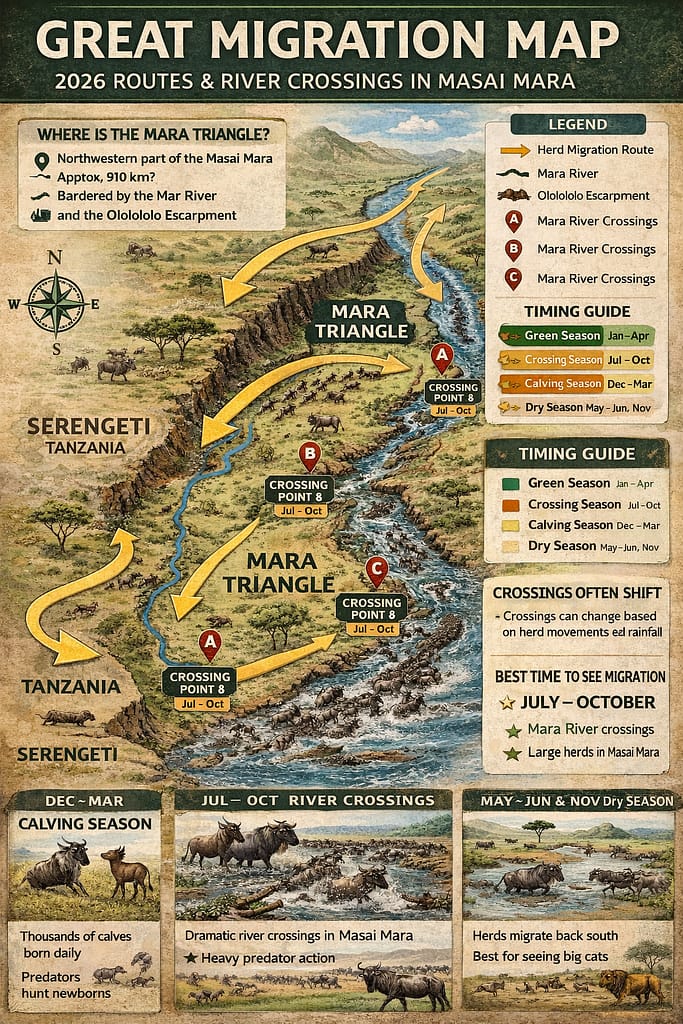
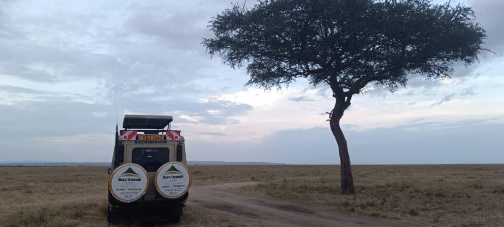
The Mara Triangle is the western third of the Masai Mara National Reserve. When you look at a Great Migration Kenya map, you will see it is separated from the rest of the reserve by the Mara River. This natural barrier often means fewer vehicles and a more exclusive experience for you. Many of the animals enter the Triangle first when coming from the Serengeti. Therefore, a Great Migration Kenya map often highlights this area as a hotspot for early season action. We operate extensively here and know every hidden corner. The Mara Triangle map is less cluttered with camps, which means more wilderness for you. Using the Great Migration Kenya map helps you appreciate this unique geography.
It is about quality of experience.
Because there are fewer entry gates, the traffic is managed better. A Great Migration Kenya map will show you that the Triangle has easy access to major crossing points. You don’t have to drive for hours to get to the river. This proximity is a huge advantage during the migration season. When you study the Great Migration Kenya map, you see that the escarpment provides a stunning backdrop to your photos. The concentration of animals here is phenomenal. We can take you to spots on the Great Migration Kenya map where you might be the only vehicle for miles. It feels private and personal. This is why understanding the Great Migration Kenya map is so important for choosing your safari operator.
Exclusive Access
Strategic Location
Stay at a camp inside the Mara Triangle to avoid long commutes to the river in the morning.
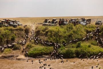
River Crossings Details on the Great Migration Kenya Map
The crossings are the main event.
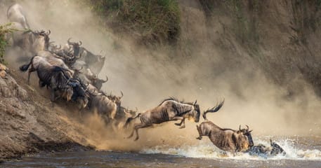
Everyone wants to see the wildebeest brave the water. A detailed Great Migration Kenya map will specifically mark the “crossing points” along the winding Mara River. These are not bridges; they are steep banks where animals leap into the unknown. Knowing where these are on the Great Migration Kenya map allows us to position ourselves early. The anticipation is palpable as the herds gather at the water’s edge. You can feel the energy in the air. We use the Great Migration Kenya map to predict which crossing point is most likely to be active based on herd direction. It is a game of patience and strategy. The Mara River crossings are dangerous and dramatic, and seeing them on a map helps you understand the peril the animals face.
It is a life and death struggle.
Crocodiles lie in wait, and the current is strong. When you look at the river on the Great Migration Kenya map, remember it is a lifeline and a barrier. The map helps you trace the path of the river and identify the bends where crossings are frequent. We ensure you are parked safely and respectfully. Using the Great Migration Kenya map, we can navigate between different crossing points if one is quiet. This flexibility is crucial. The Masai Mara migration highlights are centered around these river events. By familiarizing yourself with the Great Migration Kenya map, you understand why we rush to the river when the radio crackles with news. It is the pulse of the migration.
The Danger Zones
Strategic Positioning
Bring a dust mask or scarf, as the waiting vehicles can kick up a lot of dust near the river.
Analyzing Weather Patterns with the Great Migration Kenya Map
Weather dictates the movement.
The rain is the driving force behind the entire migration. A smart traveler uses the Great Migration Kenya map in conjunction with weather forecasts. If it rains in the north, the herds move north. If it is dry, they might stall. Understanding Masai Mara July weather helps you know that it is usually cool and dry, perfect for viewing. The Great Migration Kenya map helps you plot out routes that are passable during different weather conditions. We know which tracks get muddy and which remain firm. Even Masai Mara January weather affects the residual herds, and the map helps us find them. A Great Migration Kenya map is your guide to navigating the terrain regardless of the sky.
Seasons change the experience.
The “Green Season” or rainy season changes the landscape completely. While the migration peaks in the dry season, the Great Migration Kenya map is still useful later in the year. For instance, Masai Mara February weather is hot and dry, often leading to excellent predator sightings near water sources marked on the map. Masai Mara in December weather brings the short rains and lush grass. The Great Migration Kenya map helps us identify high ground where animals congregate to avoid the mud. It is essential for planning a comfortable drive. Knowing the best time to visit Kenya safari Masai Mara involves studying both the calendar and the Great Migration Kenya map. They go hand in hand.
Rain and Movement
Seasonal Road Conditions
Pack layers; mornings can be very cold even if the afternoon gets hot.
Masai Mara on the Map: Key Locations to Visit
Photography Strategy Using the Great Migration Kenya Map
Photographers need to plan angles.
The sun’s position changes relative to the river, and a Great Migration Kenya map helps you plan for light. You want the sun behind you to illuminate the crossing animals. By looking at the orientation of the river on the Great Migration Kenya map, we can decide whether to go to the east or west bank. This ensures your photos are crisp and well-lit. We know that lighting can make or break a shot. The Great Migration Kenya map is a tool for artistic composition as much as navigation. It helps us find high vantage points for landscape shots. Capturing the scale of the herds requires space, which the map reveals.
Predicting the action.
Good photography is about being ready. If we see herds moving towards a specific point on the Great Migration Kenya map, we get there ahead of them. This allows you to set up your gear and check your settings. We help you identify the Masai Mara migration guide points that offer the cleanest backgrounds. The Great Migration Kenya map also helps us avoid crowds, so you don’t have other cars in your frame. We want you to go home with award-winning images. Whether you are a pro or an amateur, the Great Migration Kenya map improves your odds. It helps us visualize the shot before it happens.
Lighting and Angles
avoiding the Crowds
Use a bean bag to stabilize your camera on the safari vehicle window for sharper images.
Accommodation Choices on the Great Migration Kenya Map
Where you sleep matters.
Your lodge’s location on the Great Migration Kenya map determines how much sleep you get. If you are far from the action, you have to wake up very early. We recommend choosing camps that are centrally located or close to the river. The Great Migration Kenya map shows you exactly where the lodges are relative to the crossing points. Staying in the Mara Triangle often puts you right in the thick of it. We can help you interpret the Great Migration Kenya map to find the best accommodation for your budget and needs. Being close means you can return for lunch and go back out easily.
Luxury in the wild.
There are many camps, from rustic to ultra-luxury. A Great Migration Kenya map helps you see which camps offer views of the plains or the river. Imagine watching the herds from your tent! That is possible if you use the Great Migration Kenya map to select the right spot. We partner with the best camps that offer strategic advantages. The Great Migration Kenya map ensures you are not stuck in a transit zone but in a prime viewing area. It maximizes your immersion in nature. Your accommodation is your basecamp, and the map ensures it is well-positioned.
Proximity to Action
Camp Views
Ask for a packed breakfast so you can stay out all morning without returning to camp.
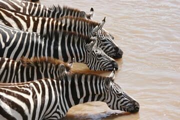
Wildlife Beyond Wildebeest on the Great Migration Kenya Map
It is not just about the gnus.
The migration attracts a host of other animals. A Great Migration Kenya map helps you locate territories of big cats who follow the feast. Lions, leopards, and cheetahs are abundant during this time. By knowing the terrain on the Great Migration Kenya map, we can find the rocky outcrops or “kopjes” where lions like to rest. Zebras and gazelles also travel with the wildebeest. The Great Migration Kenya map helps us find the open plains where cheetahs hunt gazelles. It is a complete ecosystem in motion.
Scavengers and birds.
Vultures circling in the sky often indicate a kill or a crossing. We use these visual cues along with the Great Migration Kenya map to find action. Hyenas are also very active, cleaning up after the predators. The river banks marked on the Great Migration Kenya map are home to massive hippos and crocodiles. You get to see the diversity of the Masai Mara in one trip. The Great Migration Kenya map reminds us that every area has different residents. We explore diverse habitats to show you the full range of wildlife.
Predator Hotspots
Diversity of Species
Keep an eye out for vultures; they are nature’s GPS for finding predator action.
What You Will Experience on Your 3 Days Maasai Mara safaris package with Mara Triangle Safaris
Common Questions About the Great Migration Kenya Map
We know you have questions.
Planning a trip of this magnitude can be confusing. We use the Great Migration Kenya map daily, but we know it might be new to you. Here are the most common questions we get asked by travelers. We hope these answers help you feel more prepared to use your Great Migration Kenya map.
What is the Great Migration?
The Great Migration is the annual movement of over two million wildebeest, zebras, and gazelles. They travel between the Serengeti in Tanzania and the Masai Mara in Kenya in search of rain and grass. It is a continuous cycle shown on any Great Migration Kenya map.
When is the best time to see the Great Migration?
The best time is generally from July to October. This is when the herds are typically in the Masai Mara crossing the river. Your Great Migration Kenya map will focus on the river crossings during these months.
Where are the best viewing spots for the Great Migration?
The best spots are along the Mara River for crossings and the open plains of the Mara Triangle. A Great Migration Kenya map highlights areas like Paradise Crossing and Lookout Hill. These areas offer density and drama.
What animals can you see during the Great Migration?
Besides wildebeest and zebra, you will see lions, leopards, cheetahs, hyenas, crocodiles, and hippos. The influx of prey attracts all the major predators. A Great Migration Kenya map helps locate their territories.
How do I use a migration map?
You use a Great Migration Kenya map to understand the direction of the herds and the layout of the reserve. It helps you plan where to stay and where to drive. We guide you through it on safari.
What is the best time to visit Masai Mara for migration?
August and September are often considered peak months for river crossings. However, July offers the arrival excitement. Consult a Great Migration Kenya map to see historical movements for your chosen month.
What are the challenges of viewing the Great Migration?
The main challenges are crowds at crossings and the unpredictability of nature. Sometimes the animals wait days to cross. A Great Migration Kenya map helps us find quieter spots.
How do I book a Great Migration safari?
You should book with a reputable operator like us who knows the terrain. We handle all the logistics and guiding. Use a Great Migration Kenya map to discuss your preferred itinerary with us.
Trust your guide; we have years of experience reading the bush and the map!

Ready to witness the magic?
The map is just the beginning; the real adventure starts when you get here. We at Mara Triangle Safaris are passionate about showing you the spectacle of the migration. Let us be your guides on this incredible journey using our expert knowledge and the Great Migration Kenya map.
Take the next step and book with Mara Triangle Safaris today. Visit our contact page at https://maratrianglesafaris.co.ke/contact/ to start planning your dream trip!
Contact us today to start planning your unforgettable Kenyan journey!
Email: info@mara-triangle-safaris
deals@maratrianglesafaris.co.ke
Phone: (+254) 705 635 886
(+254) 768 212 702
Venus complex, Northern bypass, 1st floor room 4107
Website: https://maratrianglesafaris.co.ke/contact/
Visit our contact page at https://maratrianglesafaris.co.ke/contact/ to get in touch.
We can’t wait to welcome you to Kenya!