
A Complete Mara Triangle Map and Travel Guide
Explore the Mara Triangle with our complete navigation guide. Learn to read Mara Triangle Map, plan routes, spot wildlife, and make the most of your safari adventure!
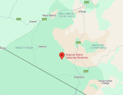
A Complete Mara Triangle Map and Travel Guide
The Mara Triangle Map is a must have in your Kenya Safari Adventure. Navigating this stunning wilderness area might seem overwhelming at first, but with the right information and tips, exploring becomes much easier.
This complete guide will show you how to use maps to navigate the Mara Triangle with confidence.
By understanding the key landmarks and best wildlife viewing areas, you can make the most of every moment on your safari.
What Makes the Mara Triangle Special for Navigation?
The Mara Triangle stands out among Kenya’s safari destinations for several reasons.
It’s more compact than the main Masai Mara Reserve, covering just 510 square kilometers. That’s good news for visitors—the smaller size makes it much easier to get around. The area is also managed by the Maa Trust, which leads to better-maintained roads and clearer signage.
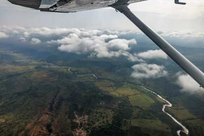
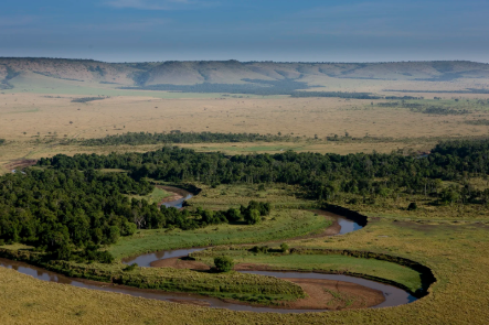
Best of all, the Mara Triangle is filled with distinct geographical features that are perfect as navigation points. The Mara River winds along the western boundary, and the Siria Escarpment rises over the eastern edge, making orientation straightforward.
Understanding Your Mara Triangle Map: The Basics
Ready to hit the road? Start by getting familiar with your map.
Key Map Symbols to Know
Look for these symbols on your Mara Triangle map:
- Dotted lines: Game drive tracks
- Solid blue lines: Rivers and water bodies
- Green shading: Forested and riverine areas
- Brown contour lines: Hills and elevations
- Red triangles: Camps and lodges
- Camera icons: Popular wildlife viewing spots
Essential Landmarks for Navigation
Worried about getting lost? Keep an eye out for these major landmarks:
The Mara River—The primary reference point, flowing north to south along the western border. If the river is in sight, you’re facing west.
Siria Escarpment—This cliff face runs along the eastern side. It’s visible from almost any location, acting as a handy compass.
Paradise Plain—Found in the middle of the triangle, this vast grassland is surrounded by acacia woodlands and is a prime spot for the Big Five.
Lookout Hill—The highest point in the region, offering 360-degree views. If directions become confusing, a trip here will give a clear view of the landscape.
Planning Your Game Drive Routes
After learning the basics, it’s time to plan some routes. Ask yourself—which animals are at the top of your must-see list?
The Classic Triangle Circuit
This classic loop covers the main habitats in about 4-5 hours:
- Start: Main entrance gate
- First stop: Paradise Plain (pause here for plains game viewing)
- Next: Mara River crossing points (look for hippos and crocodiles)
- Continue: Riverine forests (spot primates and birds)
- Last: Siria Escarpment viewpoints (photo opportunities galore)
The Migration Route
Hoping to witness the Great Migration? Track the herds with this special route:
Follow the wildebeest and zebra trails north from the Tanzanian border. Crossings usually happen at three main points along the Mara River—A (southern), B (central), and C (northern). Be sure to mark these on your map and check with guides for recent movement updates.
Navigating During Different Seasons
Navigation strategies should shift along with the seasons.
Dry Season Navigation (June to October)
During the dry months, wildlife gathers around water sources, so those areas are prime for viewing. Stick to routes that circle water points, riverine habitats, and salt licks. Road conditions are generally better, opening up more of the Mara Triangle for exploration.
Wet Season Considerations (November to May)
When the rains arrive, everything changes. Some tracks flood or become muddy, while new paths open. Wildlife spreads out, river crossings can become dangerous, and 4WD vehicles are a must. Wildlife viewing is less predictable, so flexibility is essential.
Using Technology to Enhance Your Navigation
Pair traditional printed maps with modern tech tools for the best results.
GPS Coordinates for Key Locations
Plug these into your device for extra accuracy:
- Main Gate: -1.4821°, 35.2391°
- Paradise Plain Center: -1.4156°, 35.2089°
- Popular River Crossing: -1.3982°, 35.1876°
- Lookout Hill Summit: -1.4298°, 35.2156°
Handy Mobile Apps
Boost your navigation with these apps:
- Maps.me: Works offline with topographical details
- iOverlander: Ideal for camping locations and points of interest
- eBird: Navigate to top birdwatching spots
A quick reminder: always bring a physical map as backup. Devices can run out of battery or lose signal, especially deep in the bush.
Safety Tips for Navigation
Exploring the Mara Triangle is generally safe, but always follow these basic safety rules:
Never Travel Alone
Always let someone know where you’re headed and your expected return time. If self-driving, pair up with another vehicle for peace of mind.
Stick to Designated Tracks
Don’t be tempted to go off-road—this harms the ecosystem and increases the risk of getting stuck or lost.
Carry Emergency Supplies
A well-prepared kit should include:
- Map and compass
- Charged GPS device
- Emergency satellite communicator
- First aid kit
- Extra water and snacks
Reading Animal Movement Patterns
Sharpen your navigation by learning how animals move in the Mara Triangle.
Tracks and Trails
Look for animal footpaths heading toward water or feeding grounds. These natural highways offer great wildlife viewing—but keep a respectful distance!
Vegetation Clues
Each animal has its favorite spot:
- Elephants—Acacia woodlands
- Lions—Shady areas for daily rest
- Cheetahs—Open plains for hunting
- Buffalo—Grasslands close to water
Time of Day Counts
Wildlife activity shifts throughout the day, which shapes route planning:
- Early morning (6-9 AM): Scan open plains for predators on the move
- Midday (10 AM-3 PM): Focus on shade and water sources
- Late afternoon (4-7 PM): Return to the plains for great evening action
Common Navigation Mistakes to Avoid
Here are a few common errors that can trip up even the most prepared safari-goers:
Mistake #1: Ignoring the Weather
Storms can quickly make roads impassable. Always check the weather before setting out and plan alternative routes just in case.
Mistake #2: Overestimating Distances
Bush terrain is deceiving! What appears nearby might take far longer to reach. Plan for extra travel time.
Mistake #3: Following Other Vehicles Without Knowing Why
Don’t trail other cars unless there’s a good reason—stick to your mapped route for the best experience.
Making the Most of Your Navigation Experience
Navigation doesn’t have to be a solo task or a hassle—turn it into part of the adventure!
Involve Everyone
Assign roles: one person on GPS, another scanning for wildlife, someone else tracking progress on the map. Teamwork makes the trip more engaging.
Keep Notes
A journal of routes, great wildlife sightings, and timing becomes a treasured resource for future visits or sharing with friends.
Benefit from Local Knowledge
Even if driving yourself, spend a day with a local guide. Their experience is invaluable—spotting shortcuts, reading the land, and finding hidden gems.
Your Next Steps for Mara Triangle Map Navigation
It’s time to put this knowledge to use. Take these steps to ensure a smooth safari:
- Download offline maps before leaving home
- Study all the major landmarks mentioned
- Outline 2-3 routes in advance
- Gather a full navigation and safety kit
- Brief your group on navigation basics
Navigating the Mara Triangle is more than just going from point A to point B. It’s about discovering the landscape, respecting wildlife, and creating unforgettable memories.
The Mara Triangle is waiting. With the tips and strategies in this guide, you’re ready to explore one of Africa’s most spectacular wildlife havens with confidence and care.