
A Complete Mara Triangle Map and Travel Guide
Explore the Mara Triangle with our complete navigation guide. Learn to read Mara Triangle Map, plan routes, spot wildlife, and make the most of your safari adventure!
Key features of the Mara Triangle map
- Mara River (migration crossing points)
- Oloololo Escarpment (natural boundary)
- Main game drive routes
- Wildlife hotspots
- Lodge and camp locations
A Complete Mara Triangle Map and Travel Guide
If you’re planning a safari in the Mara Triangle, having a clear, practical map is not just helpful it’s essential.
Unlike the larger Masai Mara National Reserve, the Mara Triangle is more compact, less crowded, and easier to navigate but only if you understand its layout, routes, and key wildlife zones.
This guide gives you everything you need:
- A complete Mara Triangle map breakdown
- Key locations and routes
- Migration crossing points
- Lodges and camps mapped out
- Practical navigation tips for your safari
👉 By the end, you’ll not only understand the map you’ll know how to use it to plan a better safari experience.
This complete guide will show you how to use maps to navigate the Mara Triangle with confidence.
By understanding the key landmarks and best wildlife viewing areas, you can make the most of every moment on your safari.
What is the Mara Triangle?
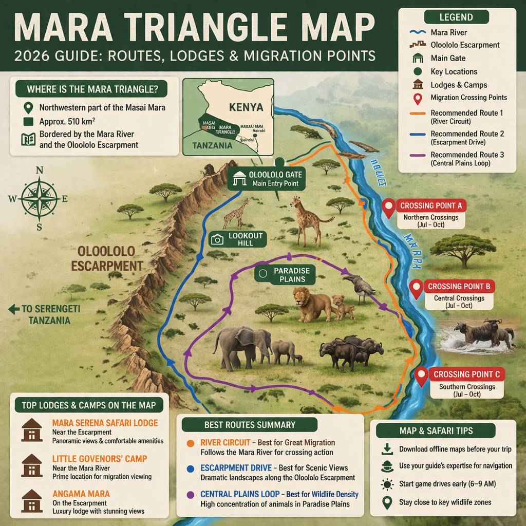
The Mara Triangle is the northwestern section of the Masai Mara National Reserve in Kenya. It covers about 510 km² and is bordered by the Mara River and the Oloololo Escarpment, making it easier to navigate than other parts of the reserve. The area is known for fewer crowds, better road conditions, and excellent wildlife viewing, especially during the Great Migration.
What Makes the Mara Triangle Special for Navigation?
The Mara Triangle stands out among Kenya’s safari destinations for several reasons.
It’s more compact than the main Masai Mara Reserve, covering just 510 square kilometers. That’s good news for visitors—the smaller size makes it much easier to get around. The area is also managed by the Maa Trust, which leads to better-maintained roads and clearer signage.
Best of all, the Mara Triangle is filled with distinct geographical features that are perfect as navigation points. The Mara River winds along the western boundary, and the Siria Escarpment rises over the eastern edge, making orientation straightforward.
Mara Triangle Map (Full Overview + How to Use It)
The Mara Triangle sits on the northwestern side of the Masai Mara ecosystem and is naturally defined by:
- The Mara River (eastern boundary)
- The Oloololo Escarpment (western boundary)
- Open savannah plains to the south
Because of these natural borders, the Triangle forms a self-contained safari zone, making navigation easier compared to other parts of the reserve.
Why the Map Matters
Most travelers underestimate this:
A map is not just for direction it helps you:
- Identify wildlife hotspots
- Choose best game drive routes
- Locate river crossing points
- Stay close to your lodge while maximizing sightings
👉 In short: the better you understand the map, the better your safari.
Where is the Mara Triangle located?
The Mara Triangle is located in southwestern Kenya, forming part of the Masai Mara ecosystem near the border with Serengeti National Park. It lies west of the Mara River and is accessed mainly through Oloololo Gate.
Understanding Your Mara Triangle Map: The Basics
Ready to hit the road? Start by getting familiar with your map.
Key Map Symbols to Know
Look for these symbols on your Mara Triangle map:
- Dotted lines: Game drive tracks
- Solid blue lines: Rivers and water bodies
- Green shading: Forested and riverine areas
- Brown contour lines: Hills and elevations
- Red triangles: Camps and lodges
- Camera icons: Popular wildlife viewing spots
Where Is the Mara Triangle Located on the Map?
The Mara Triangle is located in southwestern Kenya, bordering Tanzania’s Serengeti National Park.
Key Positioning:
- Northwest of Masai Mara
- Directly along the Great Migration route
- Adjacent to major river crossing points
Size & Scale
The Mara Triangle covers approximately 510 square kilometers, making it:
- Smaller than the main reserve
- Easier to explore in 1–3 days
- Ideal for focused wildlife viewing
Key Locations on the Mara Triangle Map
Understanding the map starts with knowing the most important locations.
1. Mara River (The Lifeline of the Triangle)
The Mara River is the most important feature on the map.
Why it matters:
- Main Great Migration crossing zone
- High concentration of wildlife
- Predator hotspots (crocodiles, lions)
👉 If you’re visiting between July and October, this is where you want to be.
2. Oloololo Escarpment
This dramatic escarpment forms the western boundary of the Triangle.
Why it matters:
- Elevated viewpoints for photography
- Scenic landscapes
- Cooler temperatures
👉 It’s one of the most underrated features on the map.
3. Lookout Hill
One of the best panoramic viewpoints in the entire Masai Mara.
From here, you can:
- See vast plains
- Track animal movements
- Get orientation of the terrain
4. Paradise Plains
As the name suggests, this is one of the richest wildlife areas.
Expect to see:
- Lions
- Elephants
- Buffalos
- Large herds of grazers
👉 This is a core game drive zone you should prioritize.
5. Oloololo Gate (Main Entry Point)
This is the primary access point into the Mara Triangle.
Why it matters:
- Entry for most safari vehicles
- Starting point for game drives
- Useful navigation reference
What does the Mara Triangle map show?
A Mara Triangle map shows key landmarks such as the Mara River, major game drive routes, wildlife hotspots, and lodge locations. It helps visitors plan efficient routes, locate migration crossing points, and navigate the reserve safely during a safari.
Best Routes on the Mara Triangle Map
Planning your route can make or break your safari experience.
Route 1: River Circuit (Best for Migration)
Start: Oloololo Gate
Route: Head east toward the Mara River
Highlights:
- Migration crossings
- Predator action
- Scenic riverbanks
👉 Best during migration season (July–October)
This classic loop covers the main habitats in about 4-5 hours:
- Start: Main entrance gate
- First stop: Paradise Plain (pause here for plains game viewing)
- Next: Mara River crossing points (look for hippos and crocodiles)
- Continue: Riverine forests (spot primates and birds)
- Last: Siria Escarpment viewpoints (photo opportunities galore)
Route 2: Escarpment Drive (Best for Views)
Drive along the base of the Oloololo Escarpment.
Highlights:
- Stunning landscapes
- Fewer crowds
- Unique photographic angles
Route 3: Central Plains Loop (Best for Wildlife Density)
Focus on Paradise Plains and surrounding areas.
Highlights:
- High concentration of animals
- Ideal for full-day game drives
What animals can you see in the Mara Triangle?
The Mara Triangle is home to the Big Five lion, leopard, elephant, buffalo, and rhino as well as cheetahs, giraffes, zebras, and large herds of wildebeest. During migration season, thousands of animals cross the Mara River, making it one of the best wildlife viewing areas in Africa.
Essential Landmarks for Navigation
Worried about getting lost? Keep an eye out for these major landmarks:
The Mara River—The primary reference point, flowing north to south along the western border. If the river is in sight, you’re facing west.
Siria Escarpment—This cliff face runs along the eastern side. It’s visible from almost any location, acting as a handy compass.
Paradise Plain—Found in the middle of the triangle, this vast grassland is surrounded by acacia woodlands and is a prime spot for the Big Five.
Lookout Hill—The highest point in the region, offering 360-degree views. If directions become confusing, a trip here will give a clear view of the landscape.
The Migration Route
Hoping to witness the Great Migration? Track the herds with this special route:
Follow the wildebeest and zebra trails north from the Tanzanian border. Crossings usually happen at three main points along the Mara River—A (southern), B (central), and C (northern). Be sure to mark these on your map and check with guides for recent movement updates.
Navigating During Different Seasons
Navigation strategies should shift along with the seasons.
Dry Season Navigation (June to October)
During the dry months, wildlife gathers around water sources, so those areas are prime for viewing. Stick to routes that circle water points, riverine habitats, and salt licks. Road conditions are generally better, opening up more of the Mara Triangle for exploration.
Wet Season Considerations (November to May)
When the rains arrive, everything changes. Some tracks flood or become muddy, while new paths open. Wildlife spreads out, river crossings can become dangerous, and 4WD vehicles are a must. Wildlife viewing is less predictable, so flexibility is essential.
When is the best time to visit the Mara Triangle?
The best time to visit the Mara Triangle is between July and October during the Great Migration, when wildebeest crossings occur along the Mara River. However, the reserve offers excellent wildlife viewing year-round, with fewer crowds during the green season from November to June.
Using Technology to Enhance Your Navigation
Pair traditional printed maps with modern tech tools for the best results.
GPS Coordinates for Key Locations
Plug these into your device for extra accuracy:
- Main Gate: -1.4821°, 35.2391°
- Paradise Plain Center: -1.4156°, 35.2089°
- Popular River Crossing: -1.3982°, 35.1876°
- Lookout Hill Summit: -1.4298°, 35.2156°
Handy Mobile Apps
Boost your navigation with these apps:
- Maps.me: Works offline with topographical details
- iOverlander: Ideal for camping locations and points of interest
- eBird: Navigate to top birdwatching spots
A quick reminder: always bring a physical map as backup. Devices can run out of battery or lose signal, especially deep in the bush.
How to Use Google Maps in the Mara Triangle
One common question:
“Can I rely on Google Maps inside Masai Mara?”
The Reality
- Network coverage is limited
- Roads are not always mapped accurately
- GPS can be inconsistent
Best Approach
- Download offline maps before arrival
- Use your guide’s knowledge
- Combine with a printed safari map
👉 Think of digital maps as support tools not your main navigation system
Can you navigate the Mara Triangle using a map?
Yes, the Mara Triangle is easier to navigate than other parts of the Masai Mara due to its clear boundaries formed by natural landmarks like the Mara River and Oloololo Escarpment. However, visitors are advised to use offline maps, guides, or local knowledge for accurate navigation.
Self-Drive vs Guided Safari (Map Perspective)
Self-Drive Safari
Pros:
- Flexibility
- Lower cost
Cons:
- Easy to get lost
- Limited wildlife tracking knowledge
Guided Safari (Recommended)
Pros:
- Expert navigation
- Better wildlife spotting
- Safer experience
👉 For most visitors, guided safaris offer significantly better results.
Where should you stay in the Mara Triangle?
The best places to stay in the Mara Triangle include lodges near the Mara River for migration viewing and camps along the escarpment for scenic views. Choosing accommodation close to key wildlife areas helps reduce travel time and improves your safari experience.
Lodges & Camps on the Mara Triangle Map
Where you stay determines your access to key areas.
Here are some of the top options:
1. Mara Serena Safari Lodge
Located near the escarpment, offering:
- Panoramic views
- Easy access to river routes
- Comfortable amenities
2. Little Governors’ Camp
Situated near the river:
- Excellent for migration viewing
- Close to wildlife hotspots
- Luxury tented experience
3. Angama Mara
Perched on the escarpment:
- One of the most luxurious options
- Incredible aerial views
- Ideal for photography lovers
💡 Pro Tip
Choose your lodge based on your priority:
Migration → stay near river
Scenic views → escarpment
General wildlife → central plains
Safety Tips for Navigation
Exploring the Mara Triangle is generally safe, but always follow these basic safety rules:
Never Travel Alone
Always let someone know where you’re headed and your expected return time. If self-driving, pair up with another vehicle for peace of mind.
Stick to Designated Tracks
Don’t be tempted to go off-road—this harms the ecosystem and increases the risk of getting stuck or lost.
Carry Emergency Supplies
A well-prepared kit should include:
- Map and compass
- Charged GPS device
- Emergency satellite communicator
- First aid kit
- Extra water and snacks
Reading Animal Movement Patterns
Sharpen your navigation by learning how animals move in the Mara Triangle.
Tracks and Trails
Look for animal footpaths heading toward water or feeding grounds. These natural highways offer great wildlife viewing—but keep a respectful distance!
Vegetation Clues
Each animal has its favorite spot:
- Elephants—Acacia woodlands
- Lions—Shady areas for daily rest
- Cheetahs—Open plains for hunting
- Buffalo—Grasslands close to water
Time of Day Counts
Wildlife activity shifts throughout the day, which shapes route planning:
- Early morning (6-9 AM): Scan open plains for predators on the move
- Midday (10 AM-3 PM): Focus on shade and water sources
- Late afternoon (4-7 PM): Return to the plains for great evening action
Common Navigation Mistakes to Avoid
Here are a few common errors that can trip up even the most prepared safari-goers:
Mistake #1: Ignoring the Weather
Storms can quickly make roads impassable. Always check the weather before setting out and plan alternative routes just in case.
Mistake #2: Overestimating Distances
Bush terrain is deceiving! What appears nearby might take far longer to reach. Plan for extra travel time.
Mistake #3: Following Other Vehicles Without Knowing Why
Don’t trail other cars unless there’s a good reason—stick to your mapped route for the best experience.
Making the Most of Your Navigation Experience
Navigation doesn’t have to be a solo task or a hassle—turn it into part of the adventure!
Involve Everyone
Assign roles: one person on GPS, another scanning for wildlife, someone else tracking progress on the map. Teamwork makes the trip more engaging.
Keep Notes
A journal of routes, great wildlife sightings, and timing becomes a treasured resource for future visits or sharing with friends.
Benefit from Local Knowledge
Even if driving yourself, spend a day with a local guide. Their experience is invaluable—spotting shortcuts, reading the land, and finding hidden gems.
Downloadable Mara Triangle Map (Recommended)
Before your trip, make sure you have:
- A printed map
- Offline Google Maps
- Lodge-provided route guides
👉 Having multiple map sources ensures you’re never lost.
Your Next Steps for Mara Triangle Map Navigation
It’s time to put this knowledge to use. Take these steps to ensure a smooth safari:
- Download offline maps before leaving home
- Study all the major landmarks mentioned
- Outline 2-3 routes in advance
- Gather a full navigation and safety kit
- Brief your group on navigation basics
Navigating the Mara Triangle is more than just going from point A to point B. It’s about discovering the landscape, respecting wildlife, and creating unforgettable memories.
The Mara Triangle is waiting. With the tips and strategies in this guide, you’re ready to explore one of Africa’s most spectacular wildlife havens with confidence and care.
FAQs About the Mara Triangle Map
Is the Mara Triangle part of Masai Mara?
Yes, it is a section of the larger Masai Mara ecosystem, managed separately for better conservation.
Can you self-drive using the map?
Yes, but it’s not recommended for first-time visitors.
Where are the best wildlife areas on the map?
- Mara River
- Paradise Plains
- Central Triangle region
What is the best map to use?
A combination of:
- Printed safari map
- Guide knowledge
- Offline GPS tools
How many days do you need in the Mara Triangle?
2–3 days is ideal to fully explore the area.
Final Thoughts
The Mara Triangle map is more than just a visual guide — it’s your blueprint for an incredible safari.
When used correctly, it helps you:
- Find wildlife faster
- Avoid crowded areas
- Maximize every game drive
👉 And ultimately, it turns a good safari into an unforgettable one.
More Reading from Mara Triangle Safaris
| Article | What You’ll Find |
|---|---|
| Is a Maasai Mara Safari Worth It? (2026 Honest Guide) | Full breakdown of costs, pros, cons, and whether it’s right for you. |
| How to Choose the Best Flights for Your Safari | Nairobi vs Kilimanjaro, baggage limits, and booking tips. |
| Safari Travel Insurance: What You Need and Why | Essential coverage for medical evacuation, trip cancellation, and gear. |
| Vaccinations for Safari: What You Need to Know Before You Go | Yellow fever, malaria pills, and travel clinic advice. |
Let’s Start Planning
The easiest way to start? Head over to our contact page.
Drop us an email at info@maratrianglesafaris.co.ke with your questions. Or give the team a call:
+254 705 635 886
+254 768 212 702
We’re here Monday through Saturday, 8:30 am to 5:00 pm East Africa time. Email works anytime – we’ll get back within 24 hours.
Tell us what you’re after. We’ll give you straight answers, honest advice, and a safari worth every penny.
No fluff. Just Africa. 🇰🇪🇹🇿